

At Sirix, we don’t just share crime statistics; we specialize in security intelligence. Our team actively researches neighborhood-level trends, crime data, and community reports to give readers more than just surface-level headlines.
Earlier this year, we published a comprehensive 2025 safety guide on Chicago, analyzing the city’s crime landscape through multiple lenses. We compared Chicago crime statistics over the years, mapped incidents across the city, and analyzed safety on the West, South, and North Sides.
We didn’t stop there! That broader horizon gave us the foundation. And now we give you the Top 10 dangerous neighborhoods in Chicago, 2025. We bring you fresh data, clear explanations, and practical advice from city dashboards, CPD/Mayor’s Violence Reduction Dashboard, local reporting (Chicago Sun-Times), and community-by-community data summaries so that you can stay informed without the confusion.
So, whether you just want to relocate or visit Chicago, check out our safety guide to navigate through the windy city’s neighborhoods:
Top 10 dangerous neighborhoods:
- West Garfield Park. Chicago’s most violent neighborhood.
- Englewood. Top hotspot for violent crime per capita.
- West Englewood. High shooting rates and a persistent crime cluster.
- East Garfield Park. One of the most dangerous west side areas.
- North Lawndale. Chicago’s top crime zones.
- Greater Grand Crossing. South side hub for robberies and violence.
- Auburn Gresham. Regularly ranked high in shootings and robberies.
- Austin.One of the most significant and most violent west side areas.
- South Shore. The top south side neighborhood for property crime.
- Roseland. Dangerous south side area with high crime concentration.
West Garfield Park. Chicago’s most violent neighborhood:
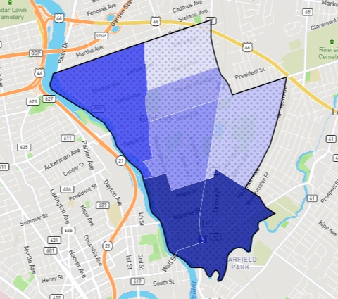
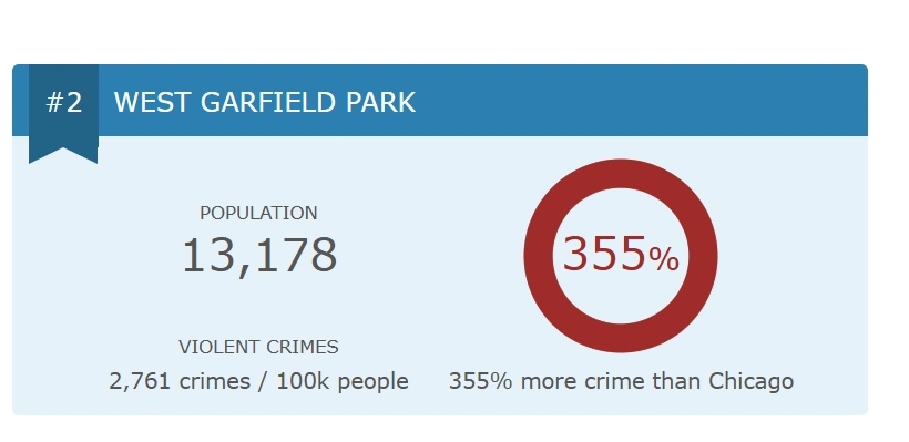
West Garfield Park is one of Chicago’s most violent neighborhoods on the West Side, with very high rates of violent crimes and property crimes.
According to Chicago Crime statistics from 2024, West Garfield Park had among the highest homicide rates in the city (≈ 97.7 homicides per 100,000 residents) in its community area.
Recent trend data for 2025 show 160 crimes per 1,000, which means roughly 16% of residents might experience or be affected by some reported crime in a year.
That’s well above most Chicago neighborhoods. Violent crime and shootings are down citywide, including in West Side neighborhoods like West Garfield Park.
What do the stats say:
Hotspots in West Garfield Park:
Blocks around Pulaski Road & West Madison Street have historically been among the worst for shootings and violent crime in West Garfield Park. Recent headlines underscore the neighborhood’s struggles with gun violence.
In June 2025, four people were wounded in a shooting on the 4500 block of West Wilcox Avenue, police said. Just weeks earlier, a 19-year-old man was fatally shot in the area, highlighting the persistent risk of youth-involved shootings.
While Chicago overall has recorded nearly 30 percent fewer murders this year compared to 2024, West Garfield Park remains a hotspot where retaliatory violence and concentrated crime clusters continue to drive high rates of shootings, according to police and local media reports.
Safer areas of West Garfield Park:
According to a report, Garfield North, Garfield East, and Garfield Northeast are the top 3 safest areas in West Garfield. Areas closer to the more commercial/active corridors are slightly better. Streets near major thoroughfares, where there is more lighting and increased foot traffic, tend to be safer. Also, portions nearer to transit lines (but still sticking to busy stops) tend to be safer than interior blocks.
Community and improvement:
City initiatives and violence-interruption programs are targeting West Side neighborhoods. Also, recent reports show that West Garfield Park has benefited from community outreach and public safety efforts, contributing to the decline in violent crime in 2025.
Englewood. Top hotspot for violent crime per capita:
Englewood continues to rank near the top for violent crime, with about 18 incidents per 1,000 residents. Fresh crime data from July 2025 paints the picture: nearly 5,000 calls for service, 182 arrests, and more than 2 million cars scanned by police cameras in just one month. Most arrests were for lower-level offenses, but felonies persist.
What does the 2025 crime data tell us?
From theft and traffic summons to felony cases and welfare checks, these numbers give a real-time picture of what’s happening on the ground today.
- High community demand for police presence. Nearly 5,000 calls for service, along with 208 additional patrol requests, indicate that residents are actively seeking help and visibility.
- Mostly lower-level crime, but serious issues persist. The majority of arrests were misdemeanors, yet 25 felonies still point to ongoing violent or high-stakes crime.
- Every day, problems stack up. Traffic violations, welfare checks, and animal welfare calls show the neighborhood isn’t only about violent crime; daily quality-of-life issues keep police busy, too.
- Technology is deeply embedded in safety efforts. With 2.1 million cars scanned and 6,200 flagged hits, surveillance tools are constantly shaping how crime is monitored and prevented.
Safer areas of Englewood:
Trouble spots like 63rd and Halsted remain flashpoints for gang activity and vacant buildings. Yet parts of Englewood South and Southwest are changing, with property values rising as families and investors put down roots.
Corridors around Racine Avenue in West Englewood are seeing some investment (commercial corridor development) and public infrastructure efforts. Community organization efforts, such as Teamwork Englewood, are active in the area.
Dangerous areas of Englewood:
63rd and Halsted is frequently cited as one of the more dangerous intersections in Englewood. Vacant buildings and gang activity are concentrated around that area.
Crime peak times:
Crime in Englewood tends to spike in evening/late-night hours, especially around transit stops and vacant lot blocks
Crime root causes:
High unemployment, underinvestment in housing, a large number of vacant lots and abandoned properties, and limited economic opportunities for youth. Gang activity remains a factor in violent crime.
Community and policy response to reduce crime in Englewood:
Englewood is not only shaped by crime stats but also by solutions: city-backed efforts like the People’s Plan, violence-interruption programs like FLIP, and community anchors like Teamwork Englewood are working daily to make streets safer.
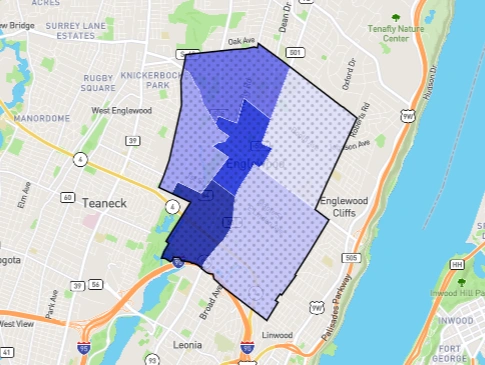
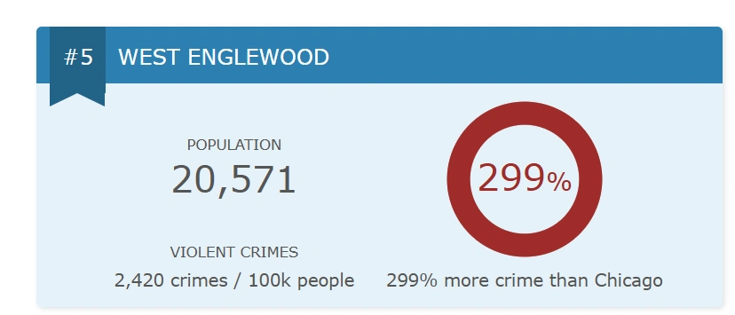
West Englewood. High shooting rates and persistent crime clusters:
According to a recent report by Crime Grade, the violent crime rate is 7.796 per 1,000 residents. The property crime rate is 28.25 per 1,000 residents for all non-violent property offenses (thefts, burglaries, etc.). The neighborhood is rated as “D” in violent crime grade and “C-” or similar for property crime.
What do the crime stats say:
The central parts of West Englewood (around commercial zones and transit stops) tend to record more incidents per capita than the southwest parts of the neighborhood. The southwest portion is relatively safer, with fewer reported incidents of property crime.
Hotspot intersections include major corridors like 63rd Street & Ashland, 63rd & Damen, and areas near the Green Line terminus. These are areas to be especially cautious in the evenings.
North Lawndale. It consistently ranks among Chicago’s top crime zones:
North Lawndale is one of the City of Chicago’s community areas with consistently high crime rates, especially violent crime, as shown in the City of Chicago crime data dashboards.
North Lawndale remains one of Chicago’s hardest-hit areas, with violent crime averaging about 7.8 incidents per 1,000 residents and property crime near 24 per 1,000.
What do the crime stats say?
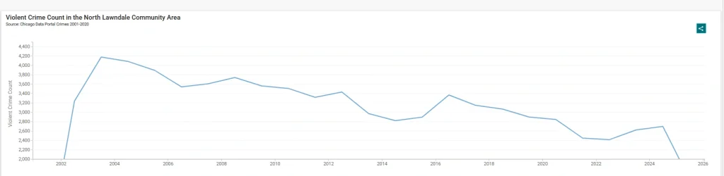
Violent crime has trended downward over recent years in North Lawndale, though still at high levels compared with many parts of Chicago. The Chicago Data Portal line graphs for North Lawndale show fluctuations but not drastic improvements yet.
Peak times for reported violent incidents tend to be later evening hours and around weekends. Property crime (including theft, break-ins) spikes often during daytime hours when homes are empty or in lots; auto theft is a recurring issue.
Most dangerous areas of Lawndale:
Despite recent declines in violent and property crime across Chicago’s 11th Police District, North Lawndale remains one of the city’s highest-risk neighborhoods. Reports show its violent crime rate is still more than 700% above the national average, and shootings have risen even as citywide numbers dropped.
Safest areas of Lawndale:
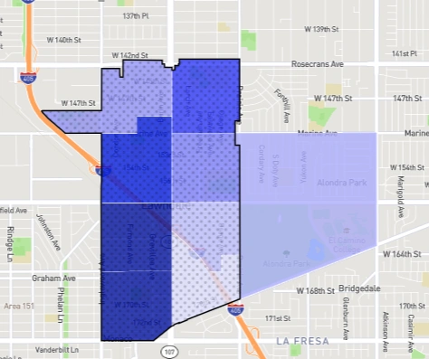
A recent report by NeighborhoodScout gives its list of the top 3 safest areas to be Lawndale Southeast, Lawndale East, and El Camino Village / Alondra Park.
Greater Grand Crossing. South side hub for robberies and violence:
Greater Grand Crossing, on Chicago’s South Side, remains one of the city’s higher-risk neighborhoods in 2025 with violent crime at roughly 9 per 1,000 residents and property crime rates well above average, according to CPD dashboards and CrimeGrade.
Hotspots of Greater Grand Crossing:
The dangerous neighborhoods of Greater Grand Crossing include the northern corridors and key intersections. Greater Grand Crossing has recently seen an uptick in concerning crimes:
- Targeted robberies. Several incidents point to a rise in robberies, with varying patterns emerging across the neighborhood.
- Scams and lures: Criminals have been reported luring victims to specific locations under false pretenses, such as fake online sales, which then escalate into armed robberies.
- Vulnerable victim targets. Older people, including those using walkers, have been targeted in armed robberies and mace attacks.
Nevertheless, some southwest pockets are comparatively calmer and show signs of improvement through community programs.
What does the crime rate say:
According to a recent report by Niche.com, Greater Grand Crossing faces violent crime rates far above the national average, with assault and robbery standing out as the biggest risks.
Assault occurs at 1,610 incidents per 100,000 residents (vs. 283 nationally), and robbery at 1,165 per 100,000 (vs. 136 nationally). Murder rates are also significantly higher, at nearly 90 per 100,000, compared to the national rate.
Auburn Gresham. Regularly ranked high in shootings and robberies
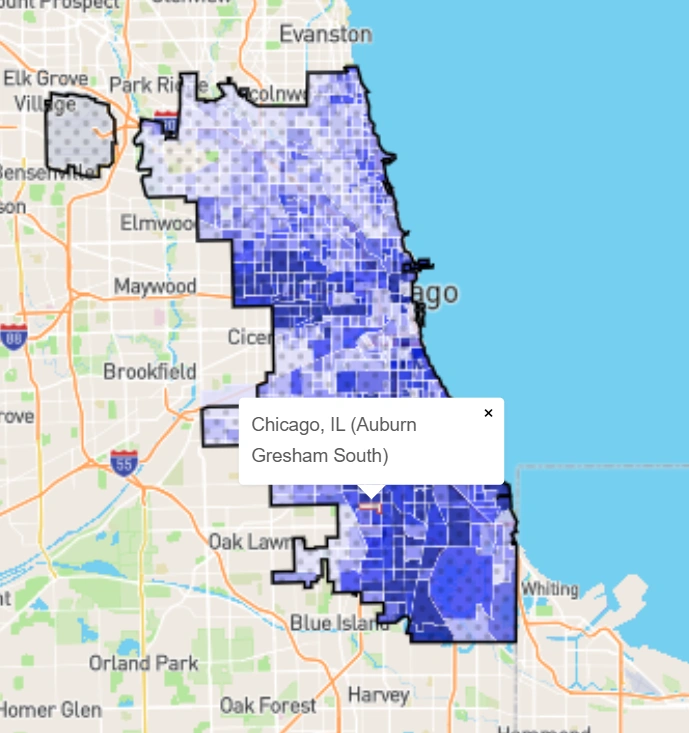
Auburn Gresham registers among Chicago’s higher-incident community areas for shootings, robberies, and certain property crimes.
According to CrimeGrade, Auburn Gresham’s violent crime rate is about 6.648 per 1,000 residents, while property crime is approximately 21.68 per 1,000 residents.
The overall crime rate (violent, property, and “other” categories) is approximately 43.70 crimes per 1,000 residents.
What do the crime stats tell us?
Auburn Gresham is a South Side neighborhood that combines classic Chicago bungalows and long-established families with some of the city’s most challenging safety statistics. Violent crime here has been measured at nearly double the citywide rate, around 8,000 incidents per 100,000 residents compared to Chicago’s 4,400, and homicide counts consistently rank it among the top 10 most dangerous areas
Hotspots in Auburn Gresham:
85th & Sangamon is one intersection with recent shootings. Also, the 8300 block of South Ashland Avenue saw a shooting.
Violent crime is concentrated during late-night hours; multiple reports cite shootings past 10 PM. For example, the incident at 85th & Sangamon.
Although violent crime is noticeable, property crime (theft, burglary, vehicle theft) makes up a larger share of total incidents in Auburn Gresham, per CrimeGrade’s breakdown.
Safer areas in Auburn Gresham:
The western part of Auburn Gresham tends to have lower crime rates than the northeast portion. CrimeGrade shows the west end is relatively safer.
Austin.One of the largest and most violent areas on the West Side:
According to a recent report, violent crime is 5.5 /1,000; property crime is 17.7 /1,000 (overall crime is 37.5 /1,000). These neighborhood-level rates are in line with several independent crime aggregates and local datasets for Austin.
City raw incident maps and dashboards show concentrated incident reporting across Austin and allow drilldown by year, type, and block. Use the City of Chicago’s open data crime map for incident details.
What do the stats tell us about Austin?
Citywide analyses show shootings and homicides fell from their 2020–2021 peaks into 2024, though lethality of shootings rose and geographic inequities persist; Austin has followed the broader city trend of modest declines but remains higher than many North Side neighborhoods.
Hotspots in Austin:
Local reporting and incident maps show repeated shootings and robberies reported along the West Lake Street corridor and nearby junctions (blocks around 4600–5600 W Lake St have appeared in recent incident reports).
Rundberg, East Riverside, and Montopolis contain a mix of commercial strips and transit stops where incidents cluster.
Safer areas of Austin:
Northern Austin pockets near the Oak Park border and the Galewood subarea generally show lower incident densities in both public datasets and community reports. Similarly, neighborhoods like Allandale, Great Hills, Hyde Park, North University, and Tarrytown are often noted for stronger safety profiles.
Local redevelopment efforts around Austin Town Hall Park and commercial TIF investments aim to stabilize some corridors.
South Shore. The top south side neighborhood for property crime:
Reports consistently show that neighborhoods on Chicago’s South Side, such as South Shore, Auburn Gresham, and West Pullman, face higher-than-average crime rates. For example, South Shore’s violent crime rate sits at 14.3 per 1,000 residents, with property crime at 49.7, while Auburn Gresham and West Pullman follow closely behind.
Crimes in South Shore:
South Shore continues to illustrate the sharp edge of Chicago’s crime challenge. News channels report fatal shootings and stabbings, CBS News documents daylight gun violence involving teens, and ABC7 highlights repeated incidents along East 79th Street. The Tribune situates these tragedies within Chicago’s 299 homicides so far in 2025!
What do the crime stats tell us?
They tell us that South Shore is not facing random incidents but a pattern of concentrated, repeated violence.
The mix of daylight shootings, stabbings after disputes, drive-bys, and youth involvement shows crime is woven into daily life rather than isolated spikes.
Poverty and gangs drive South Shore’s violence, and the city needs long-term solutions, not quick crackdowns.
Roseland. Dangerous south side area with high crime:
Several sources place Roseland’s violent crime in the mid-single digits per 1,000 residents (CrimeGrade reports ~7.42 violent incidents per 1,000).
Property crime estimates differ by source, but neighborhood totals generally range from 60 to 70 incidents per 1,000 residents per year. Since aggregators use varying methods, these figures should be viewed as approximate.
Several sources place Roseland’s violent crime in the mid-single digits per 1,000 residents (CrimeGrade reports ~7.42 violent incidents per 1,000).
Hotspots in Roseland:
Frequently reported incident locations in local coverage and incident maps include corridors near East 111th Street and South State Street, and other commercial nodes along 103rd–115th streets. Recent fatal and nonfatal shootings reported by local news cite the E 111th and S State area as an example of a hotspot in 2025.
What do the crime stats tell us?
City dashboards show violent incidents citywide fluctuating year to year; local reporting indicates spikes tied to a handful of serious incidents (shootings) rather than steady increases across every block.
Peak times for shootings and aggravated assaults are typically late afternoon through early morning hours on weekends.
Safety tips for living and visiting Chicago:
Tips for tourists about public transport, hotels, and nightlife:
- Prefer hotels and short stays near major, busy commercial corridors rather than interior residential blocks after dark.
- Use main transit corridors and daylight hours: stick to CTA/Metra hubs and avoid walking long, quiet residential blocks after dark.
- If arriving by Metra or bus, plan pickups at busy intersections or station entrances rather than side streets.
- Use rideshares or taxis for late-night trips instead of walking isolated blocks; if using CTA/Metra, travel during staffed hours and wait inside well-lit stations.
- Keep belongings secure and avoid displaying valuables; opportunistic theft and pickpocketing are more common than complex scams. (Check SpotCrime or CPD maps for recent theft clusters.)
Tips for residents:
- Park in well-lit, busy streets or secured/attended lots; avoid leaving valuables visible in cars.
- For commuting, keep your belongings out of sight, lock your vehicle, and use attended or well-lit parking lots where possible.
- Reinforce doors, utilize exterior lighting and cameras, and consider installing motion-activated lights for enhanced deterrence.
- Sign up for local CAPS/block-club alerts and monitor City crime maps for trends on your block.
- Report non-emergency incidents to 311 and emergencies to 911; use CPD online reporting for minor thefts when appropriate.
Tips for students about campus safety and late-night travel:
- Plan your travel to avoid late-night walks, use campus shuttle/escort services, or consider ride-sharing for late classes or study sessions.
- Travel in groups when possible and choose routes along commercial corridors or main streets with active foot traffic.
- Carry a charged phone, share ETA with someone you trust, and use campus safety contact numbers when available.
- Check real-time transit alerts before travel and prefer staffed stations for waiting.
Tips for solo travelers and women about apps, routes, and safety habits:
- Use safety apps (e.g., Citizen, SpotCrime) to monitor incidents and share live location with a trusted contact while moving through unfamiliar blocks.
- Stick to major, well-lit streets; avoid shortcuts through alleys, vacant lots, or empty parks.
- Prefer rideshares from designated, visible pickup points; always verify the driver and plate before entering.
- Keep your phone accessible, avoid wearing conspicuous jewelry in low-traffic areas, and carry a personal alarm or safety tool.
How are businesses staying safe across Chicago?
Rising concerns over car theft, shootings, and workplace violence put Chicago businesses at constant risk. According to CPD dashboards, property crimes remain concentrated in areas surrounding commercial corridors. Left unchecked, these threats can lead to closures, financial loss, and long-term reputational damage.
The solution isn’t reactive, it’s proactive. Businesses across Chicago are adopting Remote Video Monitoring to detect suspicious activity before it escalates.
Unlike traditional alarms that alert after the fact, remote monitoring provides 24/7 surveillance, live verification, and immediate response. Combining human expertise with advanced AI helps deter theft, reduce liability, and create safer neighborhoods where commerce can thrive.
AI-powered remote video monitoring is transforming business security in Chicago. It detects intrusions, armed individuals, and even fire hazards in real time. Trained security operators don’t just watch; they intervene through on-site speakers or dispatch authorities before threats escalate.
This proactive approach replaces outdated, reactive security models. No more waiting for alarms after a break-in or police reports filed too late. With 24/7 live monitoring, businesses close the gap between detection and response.
Frequently asked questions
What neighborhood to avoid in Chicago?
Neighborhoods like West Garfield Park are often considered among the most dangerous in Chicago due to high crime rates.
What part of Chicago has the highest crime rate?
West Garfield Park consistently records the highest crime rate in Chicago.
Which side of Chicago is the safest?
The North Side of Chicago is widely regarded as the safest, with neighborhoods like Lincoln Park and Lakeview ranking highly.
What is the poorest neighborhood in Chicago?
Riverdale is considered the poorest neighborhood in Chicago, with one of the lowest median household incomes.
Conclusion:
Chicago’s crime is shifting year to year, block by block. While neighborhoods like West Garfield Park, Englewood, and Austin remain among the city’s most dangerous in 2025, community programs, technology, and city-led safety initiatives are steadily reshaping the picture.
Whether you’re a resident, business owner, or visitor, the key is staying informed and prepared. Utilize tools such as crime dashboards, community alerts, and smart security solutions, ranging from reinforced lighting to remote video monitoring, to mitigate risks and navigate Chicago with confidence. Contact us today for a customized security solution for your business across Chicago.